Companion Resource

Apple Land Use Model
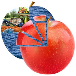
New version! Imagine the Earth as an apple. Use this large, 16.5"x17.5" apple model to demonstrate the distribution of the Earth's water and land resources. The model is two layers of durable styrene board with a handle on the back of the bottom layer. The top layer is cut into sections and held to the bottom layer by magnets. Remove the top layer of the apple to reveal the image underneath. Order this model online at agclassroomstore.com.
Procedures
Use the following narrative with the Apple Land Use Model to demonstrate how the distribution of Earth's water and land resources affects food production.
Narrative:
- Hold up the Apple Land Use Model. “This apple represents the planet Earth.”
- Remove and hold up the ¾ piece. “Nearly three-quarters of the Earth is covered in water.
- Point to the remaining ¼ of the apple. “The remaining quarter represents land area.”
- Remove and hold up the bottom 1/12 piece. “This section represents inhospitable land including deserts, mountains, and polar regions that are not suitable for people to live or grow crops.”
- Remove and hold up the next 1/12 piece. “This section represents habitable land that is not used for agriculture, including nature preserves, public land, and developed areas like roads, schools, houses, etc.”
- Remove and hold up the 3/48 piece. “This section represents agricultural land used for livestock grazing and to grow crops to feed livestock.”
- Remove and hold up the 1/48 piece. “This section represents agricultural land used to grow crops for humans to eat.
Author
National Center for Agricultural Literacy (NCAL)
Organization
National Center for Agricultural Literacy (NCAL)